Trusted by sailors since 1978 – available in print & eBook
Norway Weather and Weather Forecasts
Conditions
Winds
The solgangsbris (afternoon sea breeze) in south Norway makes for more reliable sailing conditions than in the north.
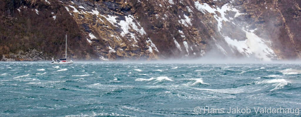
The fjords and high cliffs of the west and north coasts can cause immense gusting and funnelling, making local effects of more interest to the sailor than the weather forecast. It is best to motor or motorsail well reefed down in these conditions. When anchoring it is important to assess the topography’s potential to generate strong catabatic gusting (fallvinder).
Temperature and Precipitation
The temperature can vary drastically from year to year. Summers can be rainy and cold in one year and warm and sunny in the next. The same is valid for winters: wet and windy will be followed by dry and cold ones.
Based on the variability of the weather, we suggest that you bring a wide range of clothing, from T-shirts to heavy-duty long underwear to be worn in layers, and make sure to have good quality foul weather gear, gloves, hats and boots.
Forecasts
Weather forecasting in Norway is challenging due to the complexity of the weather systems, which are often fully occluded and spawning secondary low pressure systems by the time they reach Norwegian waters. In addition, local weather may be greatly influenced by terrain, with substantial changes in wind direction, precipitation and visibility.
However, despite these local variations and the fact that violent weather is unusual in the summer, it is still important to keep up to date with the weather situation.
Wind speeds in forecasts are given in metres per second (m/s). For a simple Rule of Thumb conversion from metres per second into knots close enough for a sailor’s purpose:
kt ≈ m/s * 2
Because of the Coastal Danger Areas and the generally small size of Norwegian motor and inshore fishing boats, gale warnings are issued for Beaufort Force 7 already. Get caught off Stadlandet in that much wind and you’ll understand why!
The Beaufort Wind Scale in Norwegian
On VHF
Norwegian coast radio stations broadcast navigation warnings, including gale warnings, as part of their Marine Safety Information Broadcasts. A short message is given on Channel 16 and the full warning is given shortly after on the regional working channels.
A local forecast is broadcast in Norwegian at 0900, 1200, 1500, 1800 and 2100 local time on the relevant working channels.
On Navtex
There are Navtex stations at Svalbard (A), Bodø (B), Vardø (C), Rogaland (L), Jeløy (M), and Ørlandet (N), all transmitting a 24-hour forecast on 518 KHz 6 times daily in English. There is no transmission on 490 KHz from Norway, Sweden or Denmark.
From The Norwegian Met Office
Their online weather forecast yr.no (scroll down to choose language) is a fabulous resource for both land and sea. You can access the forecast for a sea area by going to the map and clicking on the sea area you are interested in. It is also available as a mobile app.
Since 2024 there is a 21-day forecast for precipitation, temperature and frost risk.
They offer text forecasts in Norwegian for land areas, coastal areas and sea areas (see below for a discussion of forecast areas).
The Norwegian Met Office produces daily forecast charts for 12 UTC next day and for 12 UTC the day after. The forecast charts are based on information from numerical weather models as well as on a subjective assessment based on the meteorologists experience and the observed weather developments.
On NRK Radio
The shipping forecast is available online at NRK Radio (search on værmelding / weather forecast) and as a 24/7 recorded message on the NRK Radio app (see below for a discussion of forecast areas).
On Broadcast Radio
Norwegian FM transmissions have been phased out and replaced by the DAB+ (digital audio broadcasting) network.
If you understand spoken Norwegian, the shipping forecast is broadcast on DAB+ radio at 0545 on ch P1+ (the “senior” channel).
BBC Radio 4 forecast is now only available at 0048 and 0520, and three times daily on weekends with an additional forecast at 1200. It is no longer on LW but on BBC sounds and FM, and UK coast radio stations when in reach.
Forecast Areas
Land and Coastal
May use counties
- Though Nord Trøndelag and Sør Trøndelag are merged into one county called Trøndelag, weather forecasters may still use the former terminology, referring to the old division at Setervågen, S of Folda (Volume 1)
- Finnmark is often divided into east and west at Porsangerfjorden (Volume 2)
or regions
- ‘Østlandet’ covers the coast from the Swedish border to Kragerø (Volume 1)
- ‘Vestlandet sør for Stadt’ covers Rogaland and Vestland counties (Volumes 1 and 2)
- ‘Helgeland’ covers Nordland county south of Støtt (Volume 2)
- ‘Salten’ refers to the area between Støtt and Hamarøya (Volume 3)
- ‘Ofoten’ stretches from Nord Hamarøy to Tysfjorden, Hellemofjorden, and Ofotfjorden in to Narvik (Volume 3)
- ‘Lofoten’ and ‘Vesterålen’ are familiar terminology (Volume 3)
- and there are a lot of inland regions, which we have not defined
Sea
Based, sometimes rather loosely, on Norwegian Fishing Grounds areas. Be aware that some Norwegian areas that sound similar to those in the British shipping forecast actually cover different territory.